


A panoramic view is an attractive way of coming to know and enjoy a place.
By continuing with its work to create the Route of the Vantage Points, the Lower Aragon regional administration has, in recent weeks, fitted panoramic explanatory panels for interpreting the landscape at the Castle of the Knights of Calatrava in Alcañiz and the chapel of Santa Bárbara in La Codoñera, which complement those already existing vantage points in the towns of Belmonte de San José, Castelserás, La Ginebrosa, Torrevelilla and Valdealgorfa. These vantage points, together with those set up by the Cultural Park of the Maestrazgo in the towns of Aguaviva, Alcorisa and La Cañade de Verich, allow magnificent views of this land to be enjoyed from different natural lookouts. In the region, such diverse areas such as semi-arid steppes, Mediterranean forests and so-called premontane ecosystems can be identified.
The network of vantage points is earmarked for expansion with the incorporation of new viewpoints from which to enjoy this region.
This project is being undertaken through collaboration by the Bajo Aragón-Matarraña Local Action Group, which is partly financing its cost.
VANTAGE POINTS
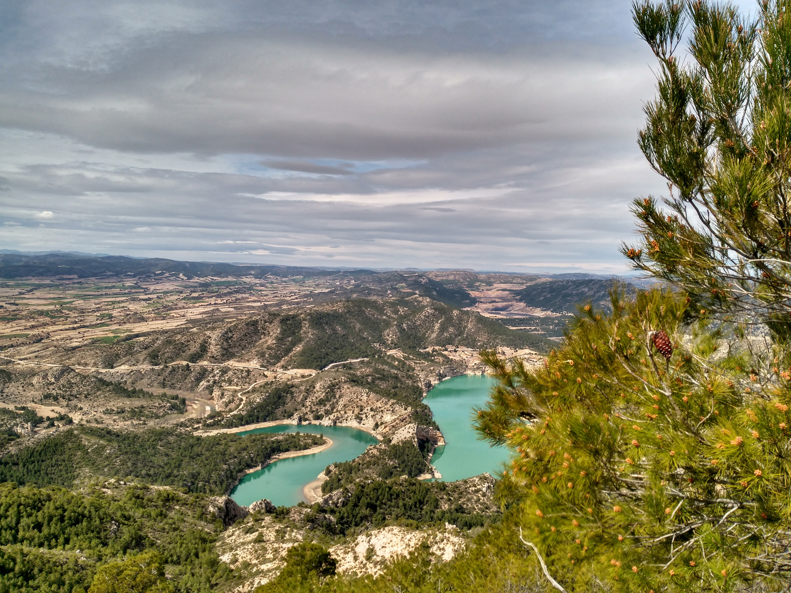
ALCAÑIZ- Castle of the Knights of Calatrava
The castle stands on one of the few high hills in this part of the region. The wide plain that is an extension of the Ebro Valley, with its gentle hills and wide open spaces begins to change here, in the valley of the River Guadalope. From this privileged height, we can see how the terrain gradually begins to resemble an area of foothills towards the east, where the Puertos de Beceite Mountains meet the Sierra de La Ginebrosa Mountains, the ridges of which can be appreciated in the distance. Below us we see the River Guadalope, which runs down from the mountains of the Maestrazgo region and partly encircles the lowland at the foot of the hill on which the early settlement of Alcañiz once stood, before it continues along its way to join the Ebro. The striking profile of Mount Tolocha is easy to make out, a natural watchtower located at the heart of the Lower Aragon region. And to the right is El Plano, a broad plain now transformed by irrigation, which extends towards the towns of Calanda, Alcorisa and Andorra. Inside this space are the Saladas, salt lakes that form a unique natural space on the steppe.
From here the presence of different solitary hills, similar to this one, can be made out: Cabezo de San Pascual, Cabezo de Cuervo and Campamento Hill (where there is an old communications tower dating from the Carlist wars), all of them cloaked with young pines resulting from reforestation efforts made in the 1960s. The existence of pre-Roman settlements at the El Palao and Alcañiz la Vieja sites confirm the importance of these hills in Alcañiz.
Texts by Fernando Zorrilla Alcaine
Scenic and Environmental Catalogue Fundación Quílez Llisterri.
CASTELSERÁS- Chapel of Santa Bárbara
Santa Bárbara Hill and its white chapel stand out in the surroundings of the town of Castelserás. This solitary high place, located between the flat agricultural lands and the sloping wild country is a wooded island where many birds seek refuge. The steep slopes of this place are thickly cloaked in Aleppo pine, with a few specimens of remarkable size and great longevity. There is also the anecdotal presence of a few specimens of Judas tree, planted along the side of the path leading to the chapel and dating from the time that the famous botanist Pardo Sastrón visited this space.
The panoramic view enjoyed from this place helps to understand the lay of the land and the transformation of the landscape in the area and in the surroundings.
Texts by Fernando Zorrilla Alcaine
Scenic and Environmental Catalogue Fundación Quílez Llisterri.
LA CODOÑERA- Chapel of Santa Bárbara
The chapel of Santa Bárbara is located not far from the town, on a spur of the surrounding mountains. Its magnificent situation resembles that of a watchtower from where the nearby countryside can be seen, making it the ideal place for interpreting the landscape of the Lower Aragon region. The surrounding land is covered by an extensive Aleppo pine forest, with a number of centenarian specimens. Access to the chapel has been improved in recent years, making it a pleasant walk.
Close to the chapel is the La Tellería Reservoir, one of the largest sources of water for livestock in the entire area.
Texts by Fernando Zorrilla Alcaine
Scenic and Environmental Catalogue Fundación Quílez Llisterri.
LA GINEBROSA- La Tarayola Vantage Point
The summit of Mount La Tarayola is an excellent vantage point that looks out over much of the central area of the Lower Aragon region. At an altitude 826 m, it forms part of the Sierra de La Ginebrosa mountains. The mountains themselves belong to the Iberian Mountain Range, and are characterised by their vegetation cover, mainly Aleppo pines, holm oaks and juniper, from which La Ginebrosa takes its name.
The proximity of this site to other singular places, such as the Pilón de San Marcos, the Desierto de Calanda convent and the Calanda Reservoir give this place a special appeal, particularly on clear days, and a visit is essential for an educational interpretation of the landscape of a large part of the Lower Aragon region.
Texts by Fernando Zorrilla Alcaine
Scenic and Environmental Catalogue Fundación Quílez Llisterri.
TORREVELILLA- El Pilón Vantage Point
Sierra de la Ginebrosa-Iberian Mountain Range.
The Sierra de La Ginebrosa mountains extend through the municipalities of Torrevelilla, La Ginebrosa, La Cañada de Verich and Calanda. These mountains are easily made out from many places in the Lower Aragon regions. Cloaked in forests, they extend to the nearby Calanda Reservoir. Owing to their orientation, Torrevelilla is in their shade, while the sunnier slopes face La Ginebrosa. The mountains are covered with thick Aleppo pine forests with many specimens of holm oak. Gall oaks can also be found in areas with more moisture.
A trail (PR-TE-14) runs along the ridge of these mountains, from where the view and landscape of the Mezquín Valley and much of the Lower Aragon region can be admired. The most suitable place for this is the site known as Pilón de Torrevelilla, in reference to the triangulation pillar located there. A visitor's book hangs from the pillar allowing visitors to express their feelings once they arrive at this place. Don't forget to sign it as proof of your visit to this vantage point.
Texts by Fernando Zorrilla Alcaine
Scenic and Environmental Catalogue Fundación Quílez Llisterri.
VALDEALGORFA- Chapel of Santa Bárbara
This mount (alt. 624 m) is a wooded isle set amidst terraces planted with almond and olive trees, and is very close to the N-232 road. At its highest point is the chapel of Santa Bárbara, a place offering a broad panorama of the historic Lower Aragon region, and the Terra Alta and Los Puertos regions. The chapel is an integral part of the landscape and is easily made out from a great distance. Its proximity to the road and the easy access make it a well-frequented place by tourists and locals alike. Also, the short distance trail PR-TE11 that connects the town of Valdealgorfa with La Codoñera passes close by.
The existing vegetation mainly comprises a thin cover of pine trees and Aleppo pines grow poorly here, although there are large pine specimens in the shady areas, which have served as parent trees in the colonisation of this area by the forest. Other types of vegetation include kermes oak, juniper and rosemary. For many years the Friends of the Chapel Association has taken care of maintaining the place.
This space serves as a refuge for such wildlife species as buzzards and tawny owls, with the rare presence in the surrounding area of red-rump swallow nesting sites.
Texts by Fernando Zorrilla Alcaine
Scenic and Environmental Catalogue Fundación Quílez Llisterri.